نویسنده:پروفسور ایرج عشقی
زمین ما از سه زون با مواد مختلف و ضخامت متفاوت تشکیل شدهاست. پوسته زمین لایه نسبتا نازکی است با ضخامت حدود ۱۰ تا ۹۰ کیلومتر بر روی بخش داخلی گرم، گوشته زمین (۹۰ تا ۲۹۰۰ کیلومتر) و هسته زمین (۲۹۰۰ تا ۶۳۷۱ کیلومتر). بیشتر مواد سنگی گوشته نه کاملاَ جامد و نه کاملاَ مایعند، بلکه خاصیت خمیری-روانگرایی دارند و به آرامی در گوشته با مداری به تقریب بیضیوار در حال چرخشاند(یاختههای همرفتی). در اثر این پدیده در ناحیههایی که در آنها مواد سنگی داغ به سوی بالا در حرکتاند، در اثر کاهش فشار به حالت ذوب یا روان در میآیند. در این صورت ماگمای قابل شارش به وجود میآید که از گوشته به پوسته با فشار نفوذ کرده، و در اثر آشفتگیهای زمینساختی مانند زمینساخت صفحهای میتواند تا سطح زمین بالا آیند (شکل ۱).
در اثر چنین فعالیتهای آتشفشانی ماگما به صورت آرام یا شدید و برخی اوقات با قدرت زیاد به سطح زمین رسیده و در آنجا به شکل نهشتههای جامد و سخت در میآیند. معمولیترین سنگهای جامد از این نوع در سطح جهان بازالت است.
بازالتهای همراه با پریدوتیت که سطح زمین را پوشاندهاند نشانگر این است که بخش عمده ماگمای بازالتی از گوشته سرچشمه میگیرد، زیرا پریدوتیت در سنگهای ژرف، حاوی اولیوین است که در ایجاد گوشته زمین سهم بسزایی دارد. پریدوتیت و اولیوین تنها در شرایط دما و فشار بالا ایجاد میشوند، شرایطی که در گوشته زمین برقرار است (شکلهای ۲، ۳ و ۴).
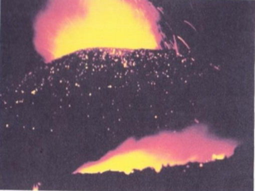
Abb. 1: Nyiragongo Vulkan-Kongo, Foto: nach R. Dreesen in Eschghi 2002
Fig. 1: Nyiragongo volcano-, Congo after R. Dreesen in Eschghi 2002
Le volcan Nyiragongo-Congo, ‘d apresˋ Dreesen dans Eschghi 2002
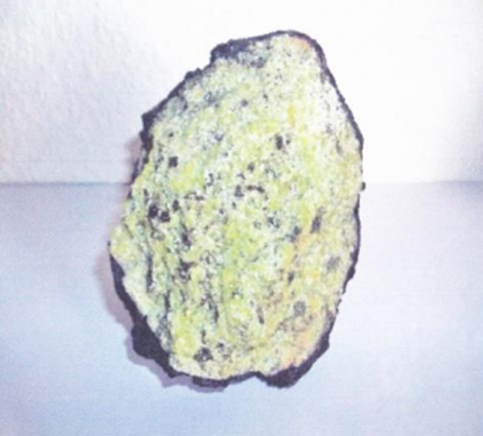
Abb. 2: Olivinknollen, die mit eine dünne Lava- Rinde umgeben ist und entstammt aus dem lnneren der Erde, Fundort: Vulkaneifel-Deutschland Foto: I. Eschghi
Fig. 2. Nodular olivine with thin lava crust, formed in the inner part of the earth. Found in the Vulkaneifel, Germany. Photograph: I. Eschghi
Nodule d’olivine avec une mince croȗte de lave, originaire de l’intérieur de
la terre. Trouvé dans le Vulkaneifel, Allemange. Photo: I. Eschghi
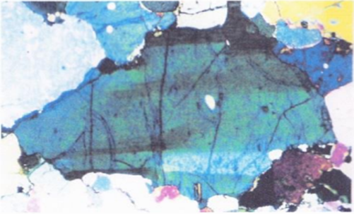
Abb. 3: Olivine unter dem Mikroskop, nach Knittel im Eschghi 2002
Fig. 3. Olivine under the microscope, after knittel in Eschghi 2002
Olivine sous le microscope, d’après knittel dans Eschghi 2002
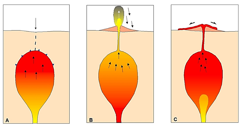
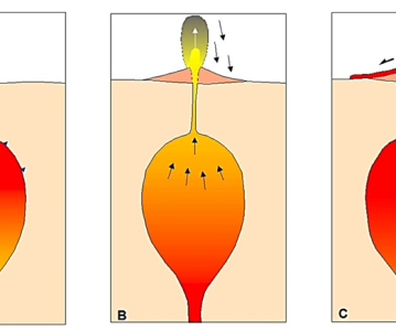
A) در اطاقک ماگمای پوستۀ زمین، فشار بالا وجود دارد.
B) با خروج ماگما به سطح زمین، فشار اطاقک کاهش ناگهانی مییابد که اغلب به صورت انفجار شدید ظاهر میشود. در این حالت بخشی از ماگمای خروجی تا ارتفاع چندین کیلومتر پرتاب میشود.
C) پس از کاهش فشار در اطاقک ماگما، خروج گدازه به حالت نسبتاً آرامی صورت میگیرد.
A) In einer Magmokommer der Erdkruste entsteht ein. überdruck.
B) Beim Austritt des Magmas on der Erdoberfläche kommt es zur Druckentlastung. Die sich meist in einer gewaltigen Explosion äußert . Das zertetzle Magma wird zum ……. bis in mehrere kilometer Hohe geschleudert
C) Nach einer Druckentlastung in der Magmakammer kann es on der Erdoberfläche zum relativ ruhigen Austluß von lava kommen
Abb.4: Die Entstehung von Vulkanen mit Darstellung der Magmakammer in der Erdkruste, Grafik nach Laschet in Eschghi 2002
Fig. 4 The origin of volcanoes with representation of the magma chamber in the earth crust, drawing after Laschet in Eschghi 2002
Origine des volcans avec représentation de la chambre de magma, dessin d’après Laschet dans Eschghi 2002
نهشتۀ ماگما و سختشدگی آن در سطح زمین
این که آیا ماگما به آرامی به سطح زمین جریان یابد و یا این که به شدت خود را به سطح زمین برساند، بستگی به ترکیب شیمیایی ماگما، بویژه تکیباتی مانند اسید سیلیسیک، بخار آب و سنگهای ذوب شده دارد. بنابراین ماگماهای متفاوت، به نهشتههای آتشفشانی با شکلهای سختشدگی متفاوت میانجامد، که بیشتر در اثر جاری شدن سریع گدازه و مواد خاکه جوشی یا تفالههای پرتاب شده، شکل میگیرد.
به طور کلی اشکال مختلف آتشفشانی را میتوان تشخیص داد: آتشفشان گنبدی، آتشفشان سپری، آتشفشان لایهای (مانند آتشفشان دماوند، شکلهای ۵ و ۶)،آتشفشان کافتی، و دریاچه آتشفشان که مار نیز نامیده میشوند مانند دریاچه آتشفشان قلعه حسنعلی در نزدیکی راین (شکلهای ۵ و ۷) و گلفشانها: آتشفشانی سرد در نزدیکی قلعه حسنعلی، شکلهای ۸ و ۹.
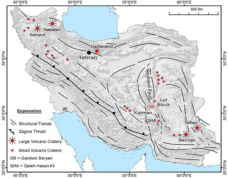
Abb.5: Übersichtskarte zum quartären Vulkanismus im Iran
(verändert vom Verfasser nach Gansser 1971 und Milton 1966/77)
Fig.5: Map of the Quaternary volcanism in Iran
(apapted by the author after Gansser 1971 and Milton 1976/77
Fig.5 : Carte du volcanisme quaternaire en Iran (modifié par l’auteur d’après Gansser 1971 et Milton 1966/77)
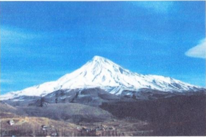
Abb. 6: Damavand-Vulkan, typische Schicht/Stratovulkan, Foto: I. Eschghi
Fig. 6. The Damavand volcano, a characteristic stratovolcano, Photograp: I. Eschghi
Le volcan Damavand, un stratovolcan typique. Photo: I. Eschghi
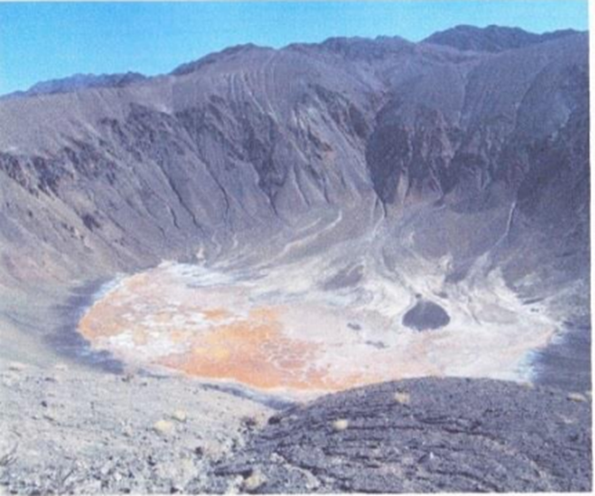
Abb. 7: Qal’eh Hasan Ali Maar/Rayen-Kerman, Foto: I. Eschghi
Fig. 7. The Qal’eh Hasan Ali Maar/Rayen-Kerman. Photograph: I. Eschghi
Le Maar de Qal’eh Hasan Ali/Rayen Kerman. Photo: I. Eschghi
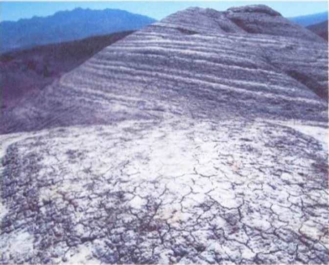
Abb. 8: Geschichteter Schlammvulkan mit Verwitterungsschuttkegel (mit Trockenrisse in unteren Bereich des Bildes), bei Qal’eh Hasan Ali/Rayen-Kerman, Foto: I.Eschghi
Fig. 8. Layered mud volcano with weathering fan (displaying dessication cracks in the lower part of the picture), near Qal’eh Hasan Ali/Rayen-Kerman, photograph: I.Eschghi
Volcan de boue stratifié avec cône d’altération (montrant des fissures de dessication en bas de la figure), près de Qal’eh Hasan Ali/Rayen-Kerman. Photo: I. Eschghi
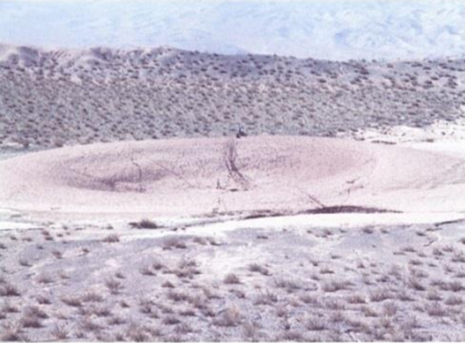
Abb. 9 Schlammvulkan Krater, Qal’eh Hasan Ali-Rayen-Kerman, Photo: A. Kermani
Fig. 9 Mud volcano crater, Qal’eh Hasan Ali-Rayen-Kerman, photo: A. Kermani
Boue cratère de volcan, Qal’eh Hasan Ali-Rayen-Kerman, photo: A. Kermani
برای مثال در آتشفشانهای لایهای اسید سیلیسیک و بخار آب در ماگما ناچیز است و از گدازههای رقیق مایع تشکیل شدهاند. آنها به آرامی از شکافها یا دهانهها بدون هیچ انفجاری بیرون میآیند. اغلب این گدازههاداغتر از گدازههای مایع گرانرو هستند، و بنابراین در زمان طولانیتری سخت شده و تا مسافتهای بیشتری جاری میشوند. با این فرآیند سطوح گدازهای وسیعی (میدان گدازهای) به وجود میآیند (نامهای دیگر آنها: مدهای بازالتی، دام بازالتی، فلات بازالتی و سطوح بازالتی است). مثالی برای میدانهای بزرگ بازالتی «حفرههای ماه» در آمریکا، «اودا اوران» در ایسلند، «تیمانفایا ناسیونال پارک» در جزیره لانزاروت در اسپانیا و «فلات گندم بریان» در ایران است.
برخلاف این یک آتشفشان کافتی دارای دودکش لوله مانند مرکزی نیست. به جای آن گدازه از یک شکاف طولی جاری میشود که در اثر آن میدان گدازهای وسیعی ایجاد میشود. به همین ترتیب ممکن است یک سری دهانه به وجود آید. آتشفشانهای کافتی میتوانند شکافهایی در ارتباط با آتشفشانهای لایهای را به وجود آورند.
فلات گندم بریان در کویر لوت در شمال شهر شهداد واقع است. این فلات به یک میدان آتشفشانی (آتشفشان لوت) با سنگهای گدازهای بازالتی جوان، که تقریباً به طور کامل تیرهاند، تعلق دارد (شکلهای ۱۰ و ۱۱). این میدان، مکانی آرمانی برای زمینشناسان، آتشفشانشناسان، و دوست داران طبیعت است. دید زیبای این منظره غریب و شکل سنگها سطح مریخ با برخوردهای شهابی آن را تداعی میکند. یکتا یعنی فلات گندم بریان. برای معرفی این پدیده طبیعی بریان، در سطح جهانی، وظیفه داریم که آن را از هر تخریبی محافظت کرده، و کوشش کنیم که به عنوان میراث طبیعی جهانی ثبت گردد.
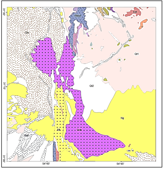
Abb. 10: Geologische Übersichtskarte des Gebietes Gandom Beryan Plateau (Lut-Vulkane) nach Geological Survey of Iran, Lakar Kuh Quadrangle J9, 1:250,000, dunkeirot punktiert: quartäre Basaltlava
Fig. 10. Overall geological map of the Gandom Beryan Platerau area (Lut volcanoes) according to the Geological Survey of Iran, Lakar Lut Quadrangle J9, 1:250.000. The red stippled area corresponds to the Quaternay basalt lava
Carte géologique générale de la région du plateau de Gandom Beryan (volvans du Lut), d’aprés le Service Géologique de I’Iran, Quadrangle de lakar Lut J9, 1:250.000. La partie en pointillé rouge correspond aux laves basaltiques Quaternaires
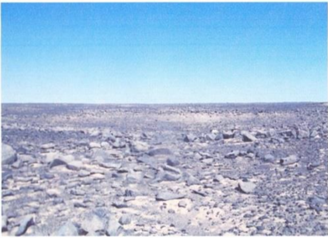
Abb. 11 Lavafeld Gandom Beryan Plateau, basaltische Lava, Foto: I. Eschghi
Fig. 11. Gandom Beryan Plateau lava field with basaltic lava. Photograph: I. Eschghi
Champ de lave du plateau de Gandom Beryan avec lave basaltique. Photo: I. Eschghi
فلات گندم بریان به احتمال زیاد از نوع دهانهای (شکلهای ۱۲ و ۱۳) آتشفشانهای کافتی است، که در اثر آشفتگیهای زمینساختی (اشفتگی نایبند، شکلهای ۵ و ۱۰) به وجود آمدهاست.
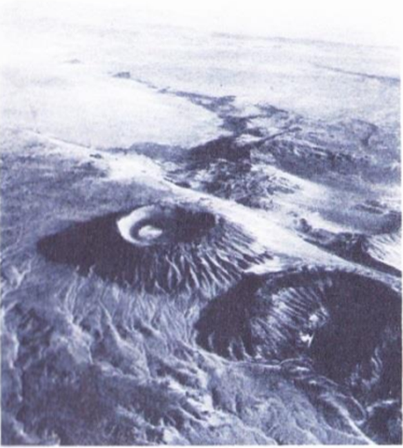
Abb. 12: Zwei Krater eines quartären Basaltvulkan nordwestlich des Gandom Beryan Plateau (Lut-Vulkane) mit deutlichen Verwitterungserscheinungen am Kraterhang, Foto: H. M. Kluyver
Fig. 12. The Gandom Beryan Plateau (Lut volcanoes) with conspicuous weathering phenomena on the crater flanks. Photograph: H. M. Kluyer
Deux cratéres d’un volcan de basalte Quaternaire, situés au Nord-Ouest du Plateau de Gandom Beryan (volcans du Lut) montrant des phénoménes d’altérations bien visibles sur les flancs du cratére. Photo: H. M. Kluyver
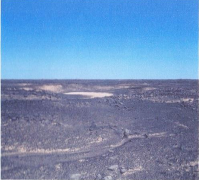
Abb. 13: Flacher Vulkankrater in der Bildmitte südlich des Gandom Beryan Plateaus, Foto: I. Eschghi.
Fig. 13. Flat volcano crater in the middle of the picture, located S of the Gandom Beryan Plateau. Photograph: I. Eschghi
Au centre de la figure, un cratére de volcan plat, au sud du Plateau de Gandom Beryan. Photo: I. Eschghi
کانیهای تشکیل دهنده سنگهای فلات گندم بریان
در کانیهای آزمایش شده در نمونههای سنگ فلات گندم بریان عناصر کانی زیر موجودند: آنورتیت، آلبیت، لابرادوریت، سانیدین، دیوپسید، آژیت، نفلین، اولیوین، فورستریت، فایالیت، ایلمنیت، سودو بروکیت، هماتیت، لوسیت، پرودسکیت، هورنبلند و بویتیت (شکل ۱۴).
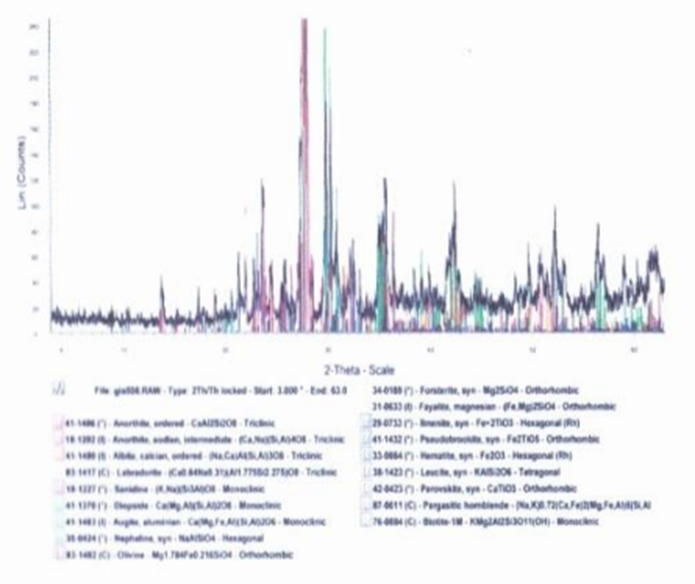
Abb. 14: Röntgendiffraktogramm (Geologisches Institut, RWTH Aachen)
Fig. 14. X-ray diffractogram (Geological Institute, RWTH Aachen)
Diffractogramme de rayons X (Institut Géologique, RWTH, Aachen)
با توجه به محتوای کانی، سنگهای موجود از نوع بازالت آنالسیمی با ترکشهایی از آنالسیم هستند که در اثر تابش آفتاب تخریب شدهاند. به این جهت «بازالت-آفتاب سوخته» نامیده میشود-آنالسیم بیشتر در حوزههای پلوتونیک و ولکانیت به صورت کانیهای فرعی به وجود میآیند (نفلین و فوید، کانیهای فلدسپاتوئید).
فلات گندم بریان در کویر لوت، بینهایت خشک و داغ است. به سبب سنگهای تیره و عدم وجود گیاه گرما شدیدتر بوده اما بدون حیات نیست. حتی با این شرایط بسیار فرین جاندار میتواند وجود داشته باشد. به سبب رنگ تیره، ظرفیت گرمایی و ذخیره گرمایی این سنگها بسیار بالا است (شکلهای ۱۵ و ۱۶).
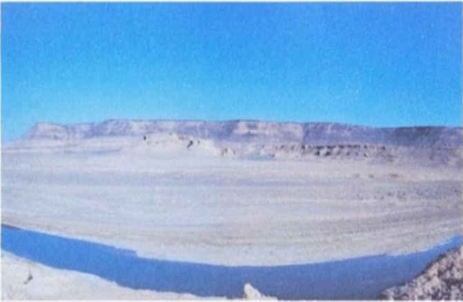
Abb. 15: Panoramablick: Rude-Schur in der Wüste Lut und das Gandom Beryan Plateau im Hintergrund, Foto: I.Eschghi
Fig. 15: Panoramic view: Rude-Schur in the Lut desert showing the Gandom Beryan plateau in the background, photograph: I. Eschghi
Vue panoramique: Rude-Schur dans le désert Lut avec le plateau Gandom Beryan dans l’arriére-plan, photo: I. Eschghi
طبق دادههای ماهوارهای اندازهگیری شده بالاترین دمای مطلق سطح زمین در سال ۲۰۰۵ در کویر لوت ۷/۷۰ درجه سانیگراد بودهاست. منطقه با بالاترین دما (قطب گرما) در کویر لوت در طول سال بر پایه وضعیت خورشید متغییر است. مقادیر قطب گرمای قبلاً تعیین شده مربوط به منطقه اوتبک در استرالیا (کوئینزلند با دمای ۳/۶۹ درجه سانتیگراد) بوده است. بنابراین اثبات شده قطب گرما نظیر قطب سرما متغییر است.
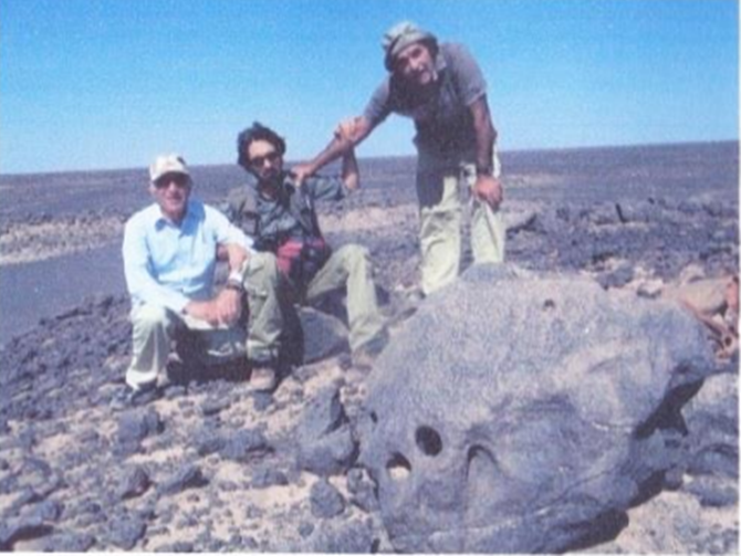
از طرف چپ ا. عشقی، م. جهانشاهی و ع. کرمانی، عکس از ح. ابراهیمزاده.
Abb. 16: Geologische und vulkanologische im Gebiet Gandom Beryan Plateau im Jahre 2011, von Links I. Escghi, M. Jahanshahi und A. Kermani, Foto: H. Ebrahimzadeh
Fig. 16: Geologic and volcanologic in the Gandom Beryan plateau area in 2011. From left to right: I. Eschghi, M. Jahanshahi and A. Kermani. Photograph: H. Ebrahimzadeh
Reconnaissance géologique et volcanologique la région du plateau de Gandom Beryan. De gauche vers la droite: I. Eschghi, M. Jahanshahi et A. Kermani. Photograph: H. Ebrahimzadeh
اشکال فرسایشی در سنگها
تغییرات دما و فرسایش در سنگهای آتشفشانی
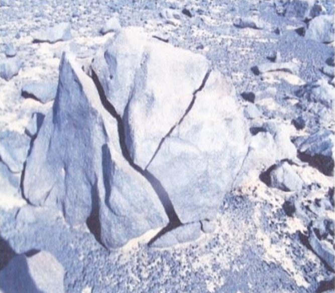
تغییرات دما به صورت پدیده تکرار افزایش و کاهش دما بر روی سنگها اثر میگذارد. اختلاف دما بطور آشکار خیلی بیش از لایه هوای بالای آنها است و انتقال آن به سنگهای واقع در زیر سطح بصورت خطی صورت نمیپذیرد. در نتیجه گرم شدن و سرد شدن باعث انبساط و انقباض مواد میشوند، اما چون تغییرات دما در سطح، بیشترین مقدار را دارد، سنگها تحت فشار قرار گرفته و در اثر آن پیوند سنگها ضعیف شده در نهایت به ترکیدگی آنها میانجامد.
تغییرات انفجاری دما یا ترکش مرکزی باعث ایجاد ترکها و شکافتگیهای شعاعی در اثر فرسایش گرمایی (تابش خورشید به سطح) به ویژه در مناطق خشک مانند سنگهای آتشفشانی فلات گندم بریان میشود (شکلهای ۱۷-۱۹).
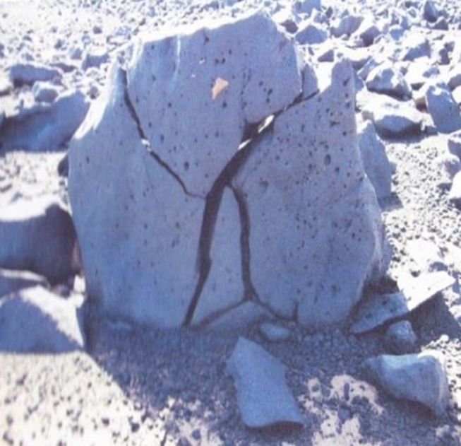
Abb. 17: Basaltblöcke mit Rissen (Kernsprünge) als Folge der ständiger Temperaturwechsel Tag/Nacht, im vulkanischen Gestein des Gandom Beryan Plateaus. Die helle Gesteinsoberfläche der normalen dunklen Gesteinsfarbe ist durch Windeinwirkung (Sandstrahl) entstanden. Foto: I. Eschghi
Fig. 17. Boulder of basalt with cracks (thermal wedges) as a result of continuous day/night temperature oscillations within the volcanic rocks of the Gandom Beryan Plateau. The pale rock surface of the normally dark-coloured rock results from eolian weathering (sand blasting). Photograph: I. Eschghi
Bloc de basalte (fissures thermiques) resultant des oscillations de température continues jour/nuit dans les roches volcaniques du plateau de Gandom Beryan. La couleur pâle de la surface de la roche de couleur normalement foncée est le résultat de l’altération éolienne (sablage). Photo: I. Eschghi
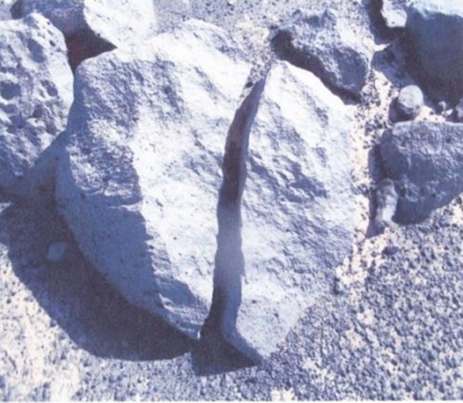
شکلهای ۱۹-۱۸: انفجار دمایی در سنگهای آتشفشانی (بازالت)، فلات گندم بریان، (عکس از ا- عشقی).
Abb. 18-19: Temperatursprengung im vulkanischen Gestein (Basalt), Gandom Beryan Plateau, Photographs: I. Eschghi
Fissuration thermique dans des roches volcaniques (basalte), Plateau Gandom Beryan. Photos: I. Eschghi
حفرههای فرسایشی در سنگهای اتشفشانی و رسوبی
در اثر اختلاف دما، تخریب کانیها، آب و هوا در سنگهای مختلف، فضاهای خالی به شکل کره یا کلیه یا سوراخها (که تافونی نیز نامیده میشود) ایجاد میشوند (عشقی ۲۰۱۳ پدیده تافونی در استان کرمان[۱])).
حفرهها در اثر ترکیبهای مختلف مواد شیمیایی، مواد پرکننده آنها و سنگهای مجاوری که در آنها قرار دارند، ایجاد میشوند. فرسایش، حفرهها و یا سوراخها در اثر از بین بردن مواد نرم داخل آنها در مقایسه با مواد سختتر سنگی مجاور بوجود میآورد.
برای مثال در توفهای آتشفشانی در قلعه حسنعلی-راین-کرمان، در توفهای آتشفشانی میمند، در توفهای آتشفشانی مرج، در سنگهای آتشفشانی غار ایوب دهج کرمان، در سنگهای آتشفشانی گندم بریان شهداد کرمان و در سنگهای رسوبی هجدک کرمان.
Zusammenfassung
Unsere Erde besteht aus drei stofflich unterschied-Zonen mit dünne Haut auf dem heißen Erdinneren mit Erdmantel und Erdkern.
Das Gesteinsmaterial des Erdmantels ist zum größten Teil plastisch-fließfähig und zirkuliert im Erdmantel sehr langsam auf etwa elliptischen Bahnen (Konvektionszellen), wobei es in Bereichen, in denen sich heißes Gesteinsmaterial aufwärts bewegt, durch Druckentlastung zum Gesteinsschmelzen bzw.- Verflüssigung kommt. Es entsteht ein fließfähiges Magma, welches vom darunter liegenden Erdmantel in die Erdkruste eindringen und durch tektonische Störungen sowie Plattentektonik bis zur Erdoberfläche aufsteigen kann (Abb.1).
Das weltweit häufigste vulkanische Erstarrungsgestein ist Basalt. Peridotit-Einschlüsse in Basaltvorkommen an der Erdoberfläche belegen, dass der größte Teil des basaltischen Magmas aus dem Bereich des Erdmantels stammt, da Peridotit ein olivinreiches Tiefengestein ist und großen Anteil am Aufbau des Erdmantels hat (Abb. 2, 3, 4).
Ob das Magma ruhig an der Erdoberfläche ausfließt oder ob es gewaltsam an die Erdoberfläche gelangt ist abhängig von der chemischen Zusammensetzung des Magmas, besonders vom Kieselsäure- und Wasserdampfgehalt einer Gesteinsschmelze. Unterschiedliche Magmen führen deshalb auch zu unterschiedlichen vulkanischen Ablagerungs- und Erstarrungsformen, die im wesentlichen durch schnell ausfließende Lava und ausgeworfenem schlackenmaterial gebildet werden.
Ganz grob lassen sich verschiedene vulkanische Formen unterscheiden: Quell- oder Staukuppen, Schildvulkane, Schichtvulkane oder Stratovulkan (z. B. Damavand-Vulkan, Abb. 5, 6), Spaltenvulkan, Maare (z. B. Maare bei Rayen, QHA = Qal’eh Hasan Ali Maare (Abb. 5, 7) und Schlammvulkane (z.B. bei Qal’eh Hasan Ali, Abb. 8, 9).
Das Gandom Beryan Plateau in der Wüste Lut liegt nördlich der Stadt Schahdad. Es gehört zu einem Vulkanfeld mit fast einheitlich dunklem, jungem basaltischen Lavagestein (Abb. 10, 11) und ist ein idealer Platz für Geologen, Vulkanologen und Naturfreunde. Der einmalige Blick auf diese bizarre Landschaft und die Gesteinsformen gleichen einer Marslandschaft mit Meteoriten-Einschlägen auf der Oberfläche.
Bei dem Gandom Beryan Plateau hendelt es sich sehr wahrscheinlich um Krater (Abb. 12 und 13) mit Spalten-Vulkanismus, der durch tektonische Störung (Nayband-Störung, Abb.5 und 10) entstanden ist.
In der untersuchten Gesteinsprobe des Gandom Beryan Plateaus sind folgende Mineralien vorhanden: Anorthite, Albite, Labradorite, Sanidine, Diopside, Augite, Nepheline, Olivine, Forsterite, Fayalite, Ilmenite, Pseudobrookite, Hematite, Leucite, Perovskite, Hornblende und Biotite (Abb. 14).
Das Gandom Beryan Plateau in der Wüste Lut ist extrem trocken und heiß. Verstärkt wird die Aufheizung noch durch dunkle vulkanische Gesteine, die vegationslos, aber nicht ohne Leben. Selbst unter extremen äußeren Bedingungen Können Lebewesen existieren. Aufgrund dieser dunklen Farbe besitzen diese vulkanischen Gesteine eine hohe Wärmekapazität und Wärmespeicherung besitzen. Plateau gehört zu den heißesten (Abb. 15-16). Die höchsten absoluten Bodenoberflächen-Temperaturen wurden im Jahre 2005 mit 70.7 C֯ in der Wüste Lut aufgrund von Satelliten Daten gemessen. Dieses Höchsttemperatur-Gebiet (Hitzepol) in der Wüste Lut wandert während des Jahres aufgrund des Sonnenstandes. Die vorher gemessenen Hitzepol-Werte stammen aus dem australischen Outback (Queensland, 69.3 C֯).
Damit ist nachgewiesen worden, dass der Hitzepol genauso wie der Kältepol wandert.
Temperatursprengung oder Kernsprünge sind radial verlaufende Fugen und Klüfte, die durch Temperaturverwitterung und lnsolation (der Einstrahlung der Sonne auf die Erdoberfläche) besonders in Trockengebieten wie in vulkanische Gesteine des Gandom Beryan Plateaus entstanden sind (Abb. 17-19).
Durch Temperatur-unterschiede, Mineralien zerfall, Wasser und Wind bilden sich kugel-bis nierenförmige Hohlräume bzm. Löcher (auch Tafoni genannt (Eschghi 2013: Tafoni Phänomene Kerman), z.B. Qal’eh Hasan Ali Rayen-Kerman, Mymand-Kerman, Marj-Kerman, Aiob Hoehle Dehej Kerman, Gandom Beryan Schahdad-Kerman und Hojedk-Kerman).
Die im Untersuchungsgebiet, Gandom Beryan Plateau typischen Sandstürme entfernen zusätzlich das durch die Verwitterung aufgelockerte Material, sodass eine ständige Erweiterung des Hohlraums erfolgt. Es wird im diesem Zusammenhang noch einmal auf das fast fehlende Wasser im Gandom Beryan Plateau hingewiesen, das in anderen Gebieten auf der Erde eine wichtige Rolle spielt. Hier im Gandom Beryan Plateau ist die Temperaturverwitterung (auch Salz) eine wichtige Faktor.
Summary
Our earth is materially composed of three different zones with different thickness. The earth crust is a relatively thin skin covering a hot interior earth consisting of a mantle and a core.
The material composition of the earth mantle is largely plastic-flowable and it circulates very slowly in the mantle along two elliptical paths (convection cells): in those areas where hot rock material moves upwards, melting or fluidization of the rocks does occur as a result of pression relief. Then a flowable magma originates that moves out of the underlying earth mantle: it can penetrate the earth crust and subsequently reach the earth’s surface along tectonic faults or via plate tectonics(Fig. 1). Worldwide, the most common volcanic igneous rock is basalt. Peridotite fragments entrapped in basalt occurrences at the earth’s surface prove that the majority of the basaltic magmas originates from the earth mantle: peridotite is an olivine-rich plutonic rock and a major component of the earth’s mantle (Figs. 2, 3, 4).
Whether the magma is quietly flowing out or violently outbursting at the earth’s surface, depends on the chemical composition of the magma, more especially on the silicium dioxide and vapour content of the rock melt. Therefore, different magmas will produce different deposition or solidification forms, essentially composed of rapidly outpouring lava or ejected scoria.
Very roughly the following types of volcanoes can be recognized: volcanic domes, shield volcanoes, composite volcanoes or stratovolcanoes (e.g. the Damavand volcano, Fig. 5, 6), fissure eruptions, Maare (e.g. the Maare near Rayen, QHA = Qal’eh Hasan Ali Maare(Figure 5, 7) and mud volcanoes (e.g. near Qal’eh Hasan Ali, Figure 8-9).
The Gandom Beryan Plateau in the Lut desert is located north of the town Shahdad. It belongs to a volcanic field with almost homogenous dark, young basaltic lavarocks (Figs. 10 and 11). It is the ideal place for geologists, volcanologists and nature lovers. The unique aspect of this strange landscape and of its rock forms strongly reminds us of the landscape of Mars with its meteorite impacts at the surface.
On the Gandom Beryan Plateau the crater (Figs. 12, 13) most probably are related to fissure eruptions that originated through tectonic faults (the Nayband fault, Figs. 5 and 10).
In the analysed rock samples from the Gandom Beryan Plateau the following minerals have been identified: anorthite, albite, labradorite, sanidine, diopsid, augite, Nepheline, olivine, forsterite, fayalite, ilmenite, pseudobrookite, hematite, leucite, perovskite, hornblende and biotite (Fig. 14).
The climate of the Gandom Beryan Plateau in the Lut desert is extremely dry and hot. Moreover, the heating up is intensified by the presence of dark volcanic rocks without any vegetation, but not without life. Even under these extreme circumstances, life forms do exist. Because of their dark colour, the volcanic rocks have an important heat and heat storage capacity(Figs. 15-16).
The highest absolute surface temperature measurement in the Lut desert is 70/7֯C (2005), measured by means of satellite data. This maximum-temperature-area (heat pole) in the Lut desert changes during the year according to the position of the sun. The formerly heat pole-measurements come from the Australian Outback area (Queensland, 69/3 ֯C).
This proves that the heat pole changes in a similar way as the cold pole.
Thermal wedging produces radial joints or cracks that originated through thermal weathering and insolation (the radiation of the sun on the earth’s surface) especially in arid areas such as that of the Gandom Beryan Plateau volcanic rock landscape (Figs. 17-19).
Because of temperature changes, mineral decomposition, water and wind action, spherical or kidney-shaped cavities (also called tafoni (Eschghi 2013: Tafoni phenomena Kerman), for example Qal’eh Hasan Ali Rayen-Kerman,Mymand-Kerman, Marj-Kerman, Aiob cave Dehej Kerman, Gandom Beryan Shahdad-Kerman and Hojedk-Kerman).
The characteristic sand storms that occur in the study area (the Gandom Beryan Plateau) remove the loose material resulting from the above mechanical weathering, with continuous subsequent enlargement of the cavities. In this particular case, the almost total lack of water on the Gandom Beryan Plateau area should be stressed, that normally should play an important role elsewhere on the earth. Here on the Gandom Beryan Plateau the thermal weathering (also salt) repersents an important weathering agent.
Résumé
Notre terre est matériellement composée de trois zones avec des épaisseurs différentes. La croûte terrestre représente une peau relativement fine, autour d’un intérieur chaud composé d’un manteau et d’un noyau. La composition du manteau est surtout plastique-fluide avec une circulation trés lente dans le manteau, suivant deux trajets elliptiques (cellules de convection): là où le matérial chaud monte, une fonte ou fluidisation de la roche aura lieu en raison de la décompression. A ce moment un magma fluide sera créé qui remonte du manteau sous-jacent: il pourra pénétrer dans la croûte terrestre et méme arriver en surface de la terre, par le moyen d’accidents tectoniques (des failles) ou par le biais de la tectonique des plaques (figure 1). Mondialement, la roche ignéé volcanique la plus commune etle basalte. Des enclaves de péridotite dans les coulées de basalte à la surface de la terre, prouvent que la majorité des basaltes trouvent leur origine dans le manteau: en effet, la péridotite est une roche plutonique riche en olivine et représente le composant majeur du manteau (figures. 2, 3, 4).
Pour savoir si un magma se répandra tranquillement ou violemment à la surface, il faudra tenir compte de la composition chimique du magma, en particulier de la teneur en dioxide de silice et de vapeur d’eau de la fonte rocheuse. C’est pour cela que des magmas de composition chimque différente, produiront des formes de solidification différentes: ce sont essentiellement des laves s’écoulant calmement ou des éjections de scories.
D’une maniére trés grossiére, on pourra distinguer les types de volcans suivants: les dômes volcaniques, les volcans boucliers, les volcans stratifiés ou stratovolcans (comme par exemple le volcan Damavand, figures 5 et 6), les volcans fissuraux, les Maars (par example ceux prés de Rayen, QHA = les Maars de Qal’eh Hasan Ali (figures 5 et 7) et les volcans de boue (par example ceux prés de Qual’eh Hasan Ali, figures 8-9)).
Le plateau de Gandom Beryan dans le désert Lut est situé au nord de la ville de shahdad. Il fait partie du champ volcanique plus au moins homogéne, composé des roches basaltiques jeunes de couleur foncée (figure 10 et 11). C’est un endroit idéal pour géologues, volcanologues et amis 0de la nature. L’aspect unique de ce paysage étrange et de ces roches, nous rappelle la surface de la planéte Mars, avec ces cratéres d’impact de météorites. Sur le Plateau de Gandom-Beryan l’origine des cratéres (figures 12, 13) est trés probablement liéé à des éruptions fissurales suivant des failles (la faille de Nayband, figures 5, 10).
Dans les échantillons de roche en provenance du plateau de Gandom-Beryan, les minéraux suivants ont pu être identifiés: anorthite, albite, sanidine, diopside, augite, néphéline, olivine, forstérite, fayalite, ilménite, pseudobrookite, hématite, leucite, pérovskite, hornblende et biotite (figure 14).
Le climat du plateau Gandom Beryan dans le désert Lut est extrémement chaud et sec. En plus, le réchauffement est amplifié par la couleur foncée des roches volcaniques, dépourvues de toute végétation, mais pas dépourvue de toute vie. En effet, même dans conditions climatologiques si extrêmes, des formes de vie existent. Par leur couleur trés foncée, les roches volcaniques ont une capacité de chaleur et de stockage thermique trés importante (figures 15, 16).
La température de surface absolue la plus élevée mesurée dans le désert Lut est de 70/7 ֯C (en 2005). Gette température élevée a pu être calculée grâce aux données de satellite.
Cette région de température maximale (pôle de chaleur) dans le désert Lut, change annuellement de place à la suite des changements de la position du soleil.
Les mesures du pôle de chaleur précédentes viennent de la région Outback d’Australie (le Queensland, 69/3 ֯C ).
Ceci prouve que pôles de chaleur changent de la même facon que les pôles de froideur.
La fissuration thermique a produit des joints et des fissures de forme radiale, attribuée à l’altération thermique ou insolation (la radiation du soleil sur la surface de la terre), particuliérement dans des régions arides comme les roches volcaniques du Plateau de Gandom Beryan figures 17-19.
A la suite des oscillations thermiques, de la décomposition des minéraux, de l’action de l’eau et du vent, des cavités sphériques ou réniformes (connues sous le nom de “tafonis” (Eschghi 2013: Phénoménes tafoni Kerman), per example Qaleh Hasan Ali volcans-Rayen-Kerman, Mymand-Kerman, Marj-Kerman, Aiob cave Dehej-Kerman, Gandom Beryan Shahdad-Kerman, et Hojedk-Kerman.
Les tempêtes de désert, typiques de notre zone d’étude (le Plateau de Gandom Beryan) enlévent le matérial d’altération qui résulte de la décomposition méchanique mentionnée plus haut, avec comme conséquence, un élargissement continu de ces cavités. Dans ce cas particulier, il faudra souligner l’absence quasi totale d’eau sur le plateau de Gandom Beryan, contrairement aux autres endroits du monde où l’eau joue un rôle trè important. Lci, sur le Plateau de Gandom Beryan, l’altération thermique (aussi le sel) représente un facteur trés important.
Referenze Reference Référence منابع
Eschghi, I. (2013): Tafoni phenomena in the Kerman province of Iran, International Journal GEO-ECO-TROP, Royal Academy for Overseas Siences of Belgium, Nr.37, 2013 (issues Juni/July 2014) Belgium.
Eschghi, I. (2002): Geo-Infoband Vulkaneifel.- Geo Zentrum Vulkaneifel und das Eifel Vulkanmuseum, 2. Auflage, 218 S. 2002, Daun.
Eschghi, I. & Kasig, W. (2011): Maare in der Eifel und im Gebiet von Kerman, Südost-Iran, Eifeljahrbuch 2011, Düren.
Gansser, A. (1971), The Tafoni Volcano (SE Iran). Eclog. Geol. Helv. 64.
Geological Survey of Iran: Explanatory text of the Lakar Kuh Quadrangle Map 1:250,000, Geological Quadrangle J9. 1983.
Milton, DJ. (1976/7/7): Qal’eh Hasan Ali Maars, Central Iran. Bull. Volcanol. Vol. 40-3, 1976-77.
[۱] پدیده تافونی در استان کرمان از ا. عشقی در مجله بینالمللی رویال آکادمی بلژیک (GEO-ECO-TROP)، شماره ۳۷، ۲۰۱۳ که در سال ۲۰۱۴ منتشر شدهاست.
Eschghi, I. (2013): Tafoni phenomena in the Kerman province of Iran, International Journal GEO-ECO-Trop, Royal Academy for Overseas Siences of Belgium, Nr. 37, 2013 (issues Juni/July 2014) Belgium